Pages

Monday 7 December 2009

FOSS4G Presentations are up

The final FOSS4G 2009 press release goes out today announcing the availability of presentations (including some videos) online.

The Free and Open Source Software for Geospatial conference really marks the end-of-year for our software development community. Thanks to the OSGeo foundation and the regional Aust-NZ group for putting on the event. In particular the organisation committee did an excellent job running the conference this year (in the middle of a recession) and not losing money.

Thanks to the sponsors for supporting both the conference and the open source spatial community. Autodesk continues to show great leadership as a gold sponsor - and I was pleased to see the amount of activity around FDO with undertakings like FDO Toolbox bringing this core functionality up to the surface for general use. OpenGeo had an amazing showing as a both a gold sponsor (which is very generous as a non profit) and with numerous well received presentations. My favourite here was a small shell demo of Python and Javascript bindings for core GeoTools functionality. Ingres was also present as a gold sponsor with the exciting announcement of their enterprise open source database (which I would love to see integrated in the rest of the open source stack).

During the conference I did not manage to catch anything from the media sponsors - let us see how that went.

Saturday 21 November 2009

GeoLivre Wrapup

Whew! I am sure tired ... and there is still some hacking to be done tonight (something about SIRGAS2000 polyconic projection that is holding back GeoServer in this market).

Yesterday I talked about the range of government representatives present; today I want to run through the sponsors and thank them - and perhaps figure out what they are doing and why they are interested in open source.
First up is OpenGeo; yes that is very confusing but apparently they had the name first! This company appears to make up the vast majority of the organising committee and I have had a great time chatting with their developers about code, scala, mapping and the fact that Brasilia is shaped like an airplane. The company has been causing trouble since 2003 and has been involved with open source from the start. The founder, Helton Uchoa, discovered source while working in the Brasilian army. Business is built around consulting with a smattering of products. This is the third time they have been involved GeoLivera.
The next sponsor is the eye of sauron and the friendly military construction department. This department is new to open source software and is developing government resource planning software by the name of OPUS. There were several presentation of OPUS over the course of the week building up a picture of an asset manager with "geospatial intelligence" (ie georeferrenced assets).
Next we have the science and technology department and geographic services department. The geographic services department had an exciting presentation of sigDesktop and sigWeb which have been in development for two years. The desktop application is C++ qt application similar to QuantumGIS. The sigWeb app combines PHP, C++ and PostGIS. It sounds like that are very happy with their results thus far.
Is a new venture with open source tools working with Brazilian state governments on environment planning. This seems to be a hot topic with every construction activity requiring a environmental impact report.

I would like to extend my thanks to the sponsors for support OSGeo Brasil in an excellent week of open source advocacy.

The local chapter has done a very impressive job of publicity for this event; and you could see their joy as the live presentation feeds brought in viewers from Sao Paulo (30%), Rio de Janeiro(12%), Recife, Salvador, Porto Alegre and Venezuela. They also broke out the traditional web 2.0 stream of tweets, blogs and the occasional dose of print media.

Apparently they sent registered mail invites to everyone government department they could throw a stone at - and this city was made specifically to house all the government. Not even the president escaped. FOSS4G should considered this approach - especially for the local area.

Wednesday 18 November 2009

Local Chapters and a Regional Conference

The Aust-NZ list is discussing what can possibly done next after FOSS4G this year. I am amused that they are ready for more less then a month after the conference - a real keen crew (or Perhaps Cameron finished that bottle of scotch Paul gave him). I am of course keen for more advocacy in the Australian region - and would really like to run more workshops and training courses. The initial response of the list has been to organise an outing to the pub in Melbourne and Brisbane!


Today I am attending the GeoLibre conference showing the opposite extreme to FOSS4G. A small local conference (small is around half the size of FOSS4G). From what I can see this is being a very effective tool in spreading the word and promoting OSGeo in the region.


Yesterday I mentioned the range of government types present at the conference; this is no doubt helped by the conference being located in capital of Brasilia. One thing I have not seen at this conference is row upon row of open laptops during the presentations; and so far I have only really talked shop with fellow presenters.


Edmar Moretti has helpfully posted a picture of the opening panel on georeferencing. I was invited to sit on this panel (in order to be available to talk about OSGeo) and only determined it was on georeferencing by listening to the translations coming through on a headset. I talked a little bit about Australia’s CRC-SI program and how the country is exploring the use of precession farming.


In the afternoon I had a chance to talk about PostGIS (my co-presenter Rafael was a bit too distracted by conference organisation so I ended up doing this one on my own). I must really thank both Paul Ramsey and his excellent talk at FOSS4G; and Simon Greener who’s guide to Oracle Spatial for PostGIS users was invaluable.


I had a couple of questions at the end of this presentation; mostly about the advent of raster support in PostGIS. The initial question was of course why? Which is a questions that I have no ready answer to - other then the fact that someone paid for it (and it is probably easier to manage via SQL?). In general modern file formats like ECW and JPEG2000 are pretty darn amazing and targeted to large rasters. The other question was of course any kind of reassurance that PostGIS can handle the vast amounts of information involved in capturing a country the size of Brasil.


This conference; and questions; really emphasis the requirement for local chapters on the ground to support the adoption of FOSS4G.


Today I am writing this as I watch a gvSig presentation; and am happy to see Sexante getting a mention. So far I am the only person with an open laptop and everyone else if very attentive (hopefully the language difference offers me an excuse in this respect). I have learned a bit more about the gvsig governance structure where groups around the world get “a vote” regardless of the size of their organisation. I am looking forward to gvSig graduating from the incubation process so I have a chance to review what they have done in this respect.

GeoLivre Day 1


Near as I can tell Jeff can get away with anything and people love him - one of the benefits of being a nice guy. Jeff had a wee bit of visa trouble and joined us via web camera for a well received morning session.

I managed to introduce OSGeo and Jeff followed up with a rundown of FOSS4G conferences and the WMS shoot out results.

One of the more interesting items I picked up was Venezuela flat out using OSGeo as a guidance point (along with OGC Standards). It seems we made the right choice signing up GeoServer last month :-)

One thing I found really healthy in todays session was the wide range of government attendance; it looks like the OSGeo Brasil chapter is going places.

Monday 16 November 2009

Saturday 24 October 2009

Code Sprint Location

Just a reminder the code sprint is today (are you awake?) Information sheet is here.

University of Technology Sydney – Ultimo Campus, Level 3, Building 6
Please remember to bring your own water :-)

Friday 23 October 2009

FOSS4G Day n+2

A big thank you to all of those who attended the GeoTools tutorial today; it was a great success - with a few surprises for me! I would like to especially thank Michael Bedward for slanting the tutorials into being visual. I was happy to see the laptops already out when I arrived in the tutorial rooms; we had a little more Eclipse in the crowd then Netbeans (but a fairly even split) with a lone VI user to keep us all honest.

I managed to catch up with the JGrass presentations this afternoon and enjoyed the information. Often we focus on the technology; and I was happy to see results. I was hoping for a bit more on climate change out of the conference and glad to see these presentations playing to a busy room.

GeoMajas presentation is walking me through how Javascript development is hard. With a few scary examples to make your blood run cold; or you just relax and work a bit harder. At the ten minuet mark we are starting to get to GWT.

Thursday 22 October 2009

FOSS4G Day n+1

Okay I know we cannot all count; rounding up some of the other posts we have a classic off-by one error (and I think as usually I have introduced the bug).
- Mark is considering starting Day 1 and Day 2
- He is supported in this numbering by Cedric with Day 1 and Day 2

It seems I have started at zero with a post about Workshops and Installfest and the commenting on the first day people started speaking (rather then doing).

Doing was a big theme for me today; with a "A Friendly Hands-on Survey of Popular Geospatial Services". The Hands-on aspect of the tutorial was a bit startling; and when asked to bring out their laptops around 40% of the people left - later it was explained that the tutorial descriptions were not published in the program.

The tutorial was a great success; thanks to Mark, Andrea and Silvia for the assistance. I will publish the workbooks online when I sort out how the conference plans to handle this; and I hope they will offer a great complement to the LiveDVD.

Conference wise I really enjoyed the demonstration theatre (where I finally got to see the GeoServer extension publishing information into world wind). It is great to see the format extension mechanism used in such a creative manner.

Also in the demo theatre was blown away by the deegree teams accomplishments with the Climate Change Integration Plugfest. I am really happy to see such a strong open source response to an interesting Challenge.

I manned the OSGeo booth for the afternoon and had several interesting conversions in response to yesterday's strong Web Processing Service showing. Apparently my enthusiasm was noticed.

I managed to catch a little bit of the GeoServer Users Group; and was excited to hear about the real world experiences (and really wish we could get more case studies - both good and bad - for the GeoServer blog).

Wednesday 21 October 2009

FOSS4G Day 1

Opening session.

Nice introduction from Cameron; kudos to thanking the local indigenous community for managing the land. I could not write down interesting statistics fast enough.

Warwick Watkins for the intro to the local market let us see if we can learn something.
  • Government monopoly on content; which is fair enough since land is the substance of land. 2500 property dealings a day. Scary that British Columbia has out sourced this management :-(
  • Platforms and service delivery; mentions Google and Wester Australia SLIP. Spatial Data Infrastructure as a goal for open source; nods to INSPIRE. In Australia ANZLIC is focused on building first generation catalogues. Setting up SLIP, Open Street Maps and OpenLayers as the second generation. Reminder to focus on data quality; regardless of what software useful.
  • Licensing as a lead up to Australia generally moving to creative commons (which is very cool to hear this at a government level). Apparently ANZLIC will be talking in this direction in their next meeting.
Richard Marles; standing in for the Minister. Plenty of funding mentioned; interesting track on IP which has been adopted by GeoScience Australia.

Raj Singh; open standards and open source; long term relationship. And a canned video CCIP? I was hoping to hear him talk. The video just said extract three times in a row. And now we are looking at an ArcMap client as part of the intro to FOSS4G. Fun. Still nice to see the ties between OGC and OSGeo working out with WMTS being an offshoot of FOSS4G 2006

Paul Ramsey; fun. "What is that we do?". How do we make a living. Interesting Paul can get away with a video since he talked through it. And then Monty Python. Nice transition to the economy of programmer attention.

----
Tutorials - wow are tutorials full. The rooms are slated for 46 people; and there was standing room only. I also saw that Dr. Koch presentation on "Custom GIS Applications using Open Source Toolkits" had gone past standing room only and had people in the hallway looking in.

This afternoons demonstrations were great; I was very impressed with the TERENO sensor data work and how in touch that community is. ESRI's demonstration of OGC SWE using 52 North plugins was polished; and it was nice to see the Tasmania services getting used.

This afternoon I am in a session focused around Web Processing Services; and although I am fascinated by the applications of this technology I am suffering a bit from the gap between the abilities opened up here and the reality of what is available today.

It was refreshing to see actually deployed systems; thanks to SCENZ-Grid for showing working examples (and hitting almost every open source project along the way!).

Goa Ang provided a great visual query builder for distributed WPS work; looks to be built on NetBeans. I would love to see this group hooked with some scientific data in order to ground the work. Really fun photo of OSGeo China; and it looks like they have monthly lecture.

Zoo is up next and they are following the recipe for open-source success. They were formed last year at FOSS4G 2008 - and they have a diverse group of collaborating organisations. Looks to be GeoExt based...with python backend.

Tuesday 20 October 2009

Workshops and Installfest

Today was the 1st day of the conference; almost a prequel. I would like to thank Mark Leslie for doing an excellent job of organising the workshops this year. And remind any of those attending that feedback forms are online... somewhere.

A special thanks to today's instructors; a fascinating range applications and adventures in spatial wonderment were displayed.

The Installfest broke up into stations around individual software packages; but we never quite got a rotation going which I was looking forward to. Ended up acting a bit more like a bird of feather hands on session.

Thai Food 4 You and The Point Pub

Thai Food 4 You, at 55 Harris Street in Pyrmont, is run by the very friendly Amy. Mark certifies that most of the dishes are gluten-free, and reasonably priced. Tucked away in a courtyard behind The Point Pub, Thai 4 You is a 15 minute walk from the convention centre, but very close to the LISAsoft office. Amy knows several of our staff by name, and can usually prepare takeaway dishes in ten to fifteen minutes, so you can call ahead on 02 9518 7848 and then start walking over to pick up. Lunch starts at $8.90, and dinner around $12. Rice and noodles, curries and stir-fries, noodle soups and satay chicken. Cash only. (This is common in takeaway restaurants so be prepared.)

The Point Pub is a good spot to wind down and enjoy a drink or three in an evening, or even a leisurely lunch. The kitchen turns out tasty steaks, burgers and fish, and the daily specials are superior to typical pub food. Downstairs is split into a pub at the front and a sit-down restaurant at the back, and you'll find more of a lounge atmosphere upstairs. Outside picnic tables are perfect for an afternoon drink. For a local brew, try Coopers or Carlton - or there's Stella Artois on tap. The Point is on the corner of Harris St and John St.

Monday 19 October 2009

Arrivals

People have been landing with various tales of travel woe for a couple of days now; I caught up with some collaborators on the GeoServer project over the weekend.

A nice group hack session; with a couple very sleepy JGrass members propped up in the corner.


Remember travel tales are safe conversation starters :-)

Thanks to the volunteers who are getting the conference materials sorted this morning.

Saturday 17 October 2009

Cheap Eats

Turkish pide (pronounced pea-day) is a quick bite similar to a calzone. Pizza-like crust enfolds fillings such as spinach, olive and feta, or chicken, mushroom and cheese. Say yes to a slice of lemon with your pide - squeezing it over the slices brings out the flavours.
Kebabs are also a popular lunch or late-night meal, and are usually available in beef, lamb, or mixed fillings. Watch out for additions such as cheese, tahbouli, and garlic sauce - these are often an extra 50 cents each. Still, kebabs and pide are one of the cheaper options to fill you up, and don't require you to get a table and sit down for an hour.
You can find both in the food court at Harbourside along Darling Harbour, but if you have more than 10 minutes to spare I recommend a quick walk to Pyrmont Kebab at Pyrmont Bridge Road & Union Street. It's just past the Pyrmont Bridge Hotel pub, and it's open late.

FOSS4G Fuel

Okay here are some ideas to for food and coffee.


View Yum in a larger map

The last requirement (internet) is a bit harder to come buy; I am currently entertaining a few earlier arrivals (Andrea and Andreas) with my local wifi. Apparently those using "3" from Europe can manage to continue service over here; internet dongles from Vodaphone have worked for previous visitors; but no good cheap solutions are available.

You can purchase internet at your hotel (but that is expensive - I paid $20 for 24 hours and went through the cap in 45 mins). Local "Macca's" (ie MacDonalds) and Starbucks sometimes offer free internet - but that is it.

The conference centre will be sorted as far as internet connections are concerned, but until then it will be difficult to check email etc. The good news is, everyone you want to send email to is here already (or delayed in the airport!).

Thursday 15 October 2009

Hunter Valley vs the Lone Star State

Last April I had an opportunity to explore the Hunter Valley. From Sydney this required an early morning train for about two hours; if there are more then three people it may be worth while to just rent a car (providing you have a designated driver). I recommend the train+tour approach which includes a designated driver.

In the case of http://www.textours.com.au/ the driver is literally named Tex. Tex fulfills your quotient for Australian language (something you may otherwise miss out on if you stay just in Sydney).

Tex picked us up from the train station in his little white bus/van and drove us around all day. We hit about five wineries, plus a cheese & gelato stop and strange fruity things such as quince paste (for cheese & crackers).

I believe the cost was around $60 per person plus train tickets, but it was worth it. Tex was hilarious, informative, and very accommodating.

http://www.hunter-valley.net/hunter-valley/gettingthere.html

Darling Harbour Eats

FOSS4G is happening next week! It seems like a long way away - and it is the other side of the world for a lot of people. Given that it is the other side of the street from LISAsoft offices I am going to try and give some pointers on where to eat.

I will start with where people will actually be:

Now this location is nothing fancy - but here is the deal. It is open 24 hours; and a lot of attendees will be jet lagged - and this place will be open.

And you know ... pancakes.

Monday 7 September 2009

Taking Boiler Plate out of Examples

I was reviewing the GeoTools example code today with Michael Bedward - preparing for an a tutorial at FOSS4G this year.

One of the things that always comes up in example code; is the requirement to "show" the result. As a result a the majority of our example code was actually examples of how create quick and dirty swing user interfaces.

So our day was spent stripping out boilerplate user interface code to a jar appropriately tilted "gt-swing" so that examples can stay focused on being examples.

Here is a small example of a wizard page for connecting to a shape file:


Here is before:


File file;


JFileChooser chooser = new JFileChooser();

chooser.setDialogTitle("Open Shapefile for Reprojection");

chooser.setFileFilter(new FileFilter() {

public boolean accept(File f) {

return f.isDirectory() || f.getPath().endsWith("shp")

|| f.getPath().endsWith("SHP");

}

public String getDescription() {

return "Shapefiles";

}

});

int returnVal = chooser.showOpenDialog(null);

if (returnVal != JFileChooser.APPROVE_OPTION) {

System.exit(0);

}

file = chooser.getSelectedFile();


And here is after:


File file = JFileDataStoreChooser.showOpenFile("shp", parent );


The other thing that has happened in cleaning up examples is a real focus on the style interfaces. Specifically going through and making sure all the new concepts introduced are accessible, and ensuring that deprecated methods are not used in example code.

Documentation harmed in the making of todays blog:

Thursday 13 August 2009

PostGIS OSX

The PostGIS experience on mac is a very slick and slippery slope.

First of all the Installers are very Slick

There are a series of nice mac installers that have been bundled up by William Kyngesburye.

And the installers are very good about beeping at you and asking you to install GDAL and PROJ prior to postgis.

And then the slippery ...

The installer don't provide much guidance on where things went ... I am used to having a postgis_template created for me by the windows installers. And all my notes are based on creating new database using that as a safe starting place.

Here were the steps needed to create my own postgis_template:
1) cd /usr/local/pgsql/bin (and then use ./ to get it to pick up the commands)
2) ./createlang plpgsql template_postgis -U postgres
3) ./psql -U postgres -f /usr/local/pgsql/share/lwpostgis.sql template_postgis
4) ./psql -U postgres -f /usr/local/pgsql/share/spatial_ref_sys.sql template_postgis

Other then that pgAdmin looks quite happy.

Wednesday 12 August 2009

CCIP 1 & 2

It looks like the climate change integration plug fest is set to take off. The hardware has arrived in boxed form; and should be online shortly. To take part join the ccip mailing list where they will sort out login credentials etc.


The size/power of these machines is a bit of a shock to me. I am not used to the wild world of virtualization and was expecting a series of dedicated machines in order to emphasis performance. It will be very interesting for me to see how well virtualization copes with the kind of load produced the different GIS stacks; and conversely if we can make a dent in this amount of processing power.

Friday 17 July 2009

FusionIO IODrive OSM

I always run into people doing interesting work at LISAsoft - this one was startling enough I decided to share.

A bloke here on the hardware side of the street has hooked up a FusionIO IODrive to OSM.
What is that thing? Terabytes of virtual memory backed by happy little clustered NAND chips.

What happened?
  • To pre-seed the top zoom-levels of OSM using mapnik are *close* to 50% quicker (based on tests done seeding a subset of the world).
  • Lower zoom levels seem to be more CPU limited at this stage
  • The IODrive should allow for many more concurrent parallel seeds to occur before we saturate IO
Yes this post has low open source content - but golly that is just so fast. And I don't want to think what one of those costs. Think we could enter it in the WMS shoot out - or is that like handing contestants a motorbike for a marathon.

Aside: This same hardware group was interested in donating hardware to an open street mapping party for FOSS4G but so far nobody returned their call? Can we make introductions or something?

Friday 3 July 2009

Out in the World

I have managed to get out in the world a bit lately, as per this GeoServer blog entry. It was really interesting to catch up with the development team that has been doing so much excellent work on "application schemas". The game plan here is to enable geoserver to publish up data according to a strict format defined by a user community. In this case the event was even more interesting as there were real live users in attendance from LandGate, GeoScience Victoria and GeoScience Australia. It was really great to go over the issues with all those involved.


A little bit of team bonding.

Monday 25 May 2009

OSGeo Branding

One of my aims with the OSGeo Foundation is to always be working on the Brand. To that end I have been pushing for member projects to share a common theme (yes that goes way beyond the idea of a little OSGeo logo in the corner of a home page).

Compare the impression made by these these two foundations:
This week I have an oppertunity to put my money where my month is - GeoTools is looking to set up a website (rather than our initial wiki page).


The idea would be to set up OSGeo project and committee websites in a similar manner.

The far side has the OSGeo logo in the corder identifying the role of the webite (in this case an OSGeo project logo is used). A bare minimum of OSGeo links under the logo; along with I hope a roll of images (both sponsors and osgeo activites) such as the foss4g link shown. Under this we could have news for the group (as shown) or perhaps a navigation tree (as per this example) or nothing. I experimented with making this a floating box ontop of the background - and it looked really nifty (but more complicated). I rejected it as it made OSGeo involvement feel like an afterthought.

A minimal navigation bar along the top; where I hope we can identify a few common headings. It would be good to move the current "project", "pages" closer to the projects they describe - perhaps as the "About" page?

The main area in this case has a two column layout; I expect this area to be single column for documentation pages.

How did I pull this together?
- grabbed the basic structure from my udig site; the MapServer community is using Sphinx so I may take that as a recommendation
- background from this presentation template - http://svn.osgeo.org/osgeo/marketing/present/ (I still need to find the background without the gradient applied in order to produce images like the CD cover from the marketting material)
- heading colors - http://wiki.osgeo.org/wiki/Marketing_Material_Samples using a paint program (#004d87 - hopefully when these materials are published they will include RGB/CMKY/Pantone)
- osgeo project logo and font selection from here - http://svn.osgeo.org/osgeo/marketing/logo/ (Bitstream Vera Sans - the logo use guidelines are written up for the previous logo - but they are very clear)
- I had to fool around with photoshop a bit to reproduce some of the effects from the marketting materials such as the green gradients.

In working on this I found a couple cases where the marketting materials are not consistent with our logo guidelines (insufficient white space around the logo; placing the logo over a complicated background; use of different colors; etc...).

Others effects look amazing - but I was unable to reproduce for a website (the use of white lettering with a blue drop shadow over top of the crop circle background - only works if I can find the background without the gradient applied).

I welcome feedback on this one; the GeoTools community is sure to provide me with some - and I am trotting these ideas out to the Marketting committee as well.

Tuesday 12 May 2009

OSGeo Templates through the Years

When the Open Source Geospatial Foundation was young (say FOSS4G 2006) I was able to find an template; that had the logo and that sort of thing sorted out. At the time I had some fun converting it to open office but the final effect was worthwhile.


I went looking for one this year and could not find anything; well that is not true I found the excellent logo usage guidelines; this info is spot on: typeface: Bitstream Vera Sans, the appropriate colors to use (in RGB, CMKY, and Pantone) and a range of logos committed into svn - including SVG.

I was able to "update" the osgeo template as shown here:


Having access to the SVG logos was great as I was able to rip apart the logo in order to generate a good "background compass", documenting the font and colors etc made this process pretty easy.

I went on to produce a workbook template; based on my experience doing uDig tutorials:
- separate out explanation from steps that need to be follow (even when it is harder to write the effort is worthwhile). I have done this making use of a block of text in the gutter - while not perfect it is the best technique I have found.
- outdent code examples; modern code seems to be more than 80 columns (sigh!)
- kill the margins not a tree; people read the PDFs these days - and margins get in the way
- leave room for author company logos on the title page (volunteers are often doing this as a marketing exercise after all)
- have page numbers for when people are binding hard copies; have the document title in a footer for when they bind several workbooks into a book

Here is what that looks like (follows the logo guidelines on font use etc...):

Taken together with the slides this is a nice polished result.

Sending these off to Tyler - looks like some mock ups have been produced from a graphic designer on this page: Marketing_Material_Samples


There is lot to like here:
- the background is great; nice and bright and cheerful and still interesting especially on the workbook cover
- I wonder if we should substitute in the appropriate OSGeo logo for the orgnaization or project putting together the materials? OSGeo - project, OSGeo - sustaining sponsor etc...

The slides leave me cold:
- the green text will vanish on almost any overhead projector
- need more elbow room for content; especially if any diagrams are used - I would hate to make them small and hard to read
- the OSGeo logo leading ahead of each individual slide title is a gets in the way of narative

When I downloaded the slides I also found the fonts used to be windows specific; and not referencing the logo guidelines (do we care?). 

I am going to put together slides and workbook template around this material and see what I come up with. Since the above are samples only my feedback should not be considered too harsh - hopefully Tyler can announce when something final from the graphic designer is available.

Monday 11 May 2009

CCIP Part 2 - Configuring GeoServer

A couple of things happened to delay this post:

  • I was hoping to get a review of the service from geoserver-devel

  • The CCIP policy was defined around how services at the conference will be handled (more of a competition – but if you have set up a service for use in a workshop that will help). Near as I can tell the good news from that angle is that Deegree are going to be involved as well

But first here is the server: http://ccip.lisasoft.com:8080/geoserver/

It does not have very many layers configured; and this is as much an interesting tale of GeoServer configuration

Clearing out the Configuration

Once I had an initial goeserver war configuration – I needed to clean out the working examples so I could start a fresh (hooking up raster data and postgis).

I was able to remove all the featuretypes; but the existing raster layers produced a NPE (bug reported GEOS-2818) - so I had to duck out to the data directory and remove the coverages directory by hand.

Aside: When I initially reported GEOS-2818 I did not choose a good title; and thus the bug was not understood; it is very important to take the time to report a problem in a clear fashion; and list the steps for a developer to reproduce the issue. It is of course amusing being caught out on this mistake :-)

Additional steps:

- change the login credentials for the configuraiton ui: /var/lib/tomcat6/webapps/geoserver/data/security/user.properties

Lessons Learned - Gray

Next up I tried setting up PostGIS; here is where we get into an amusing mistake. My postgis datastore entry "timed out" (when it changed IP address on me). When I went to correct the problem and hit "apply"/"save" etc... the green bar of happiness turned "gray". Removing all the feature types associated with this postgis turned it green again; but anytime I added a feature type it would go back to gray.


Here is the take home lesson:

- green is good

- red is an error

- gray is disabled

I had to go back into the datastore enty and mark it as "enabled"; after a timeout geoserver stops checking the entry until you go in as an administrator and fix it! That would be an amazing way to lose track of a bunch of layers...

Lessons Learned – SRS ID

I also had a merry time filling out a shapefile where the prj file was not provided. You can entry in "EPSG:4326" into the field; and that works fine for the "Generate" button to produce you a valid set of bounds - but it does not work fine enough to "Submit".


Apparently you are supposed to enter "4326".

Lessons Learned - Style Generation

I tried out the button to create a new style; and was in for a bit of hurt. The generated style did not initially include a "propertyName" for the label. Correcting this my style was still invalid when I tried it in the uDig style editor (there is an XML page where you can copy and paste styles between uDig and GeoServer or any other SLD supporting application).

I opened up a bug; attaching the generated style here: GEOS-2870

To proceed I made an interesting style for city labels where they are all rotated at 45 degrees.

Lessons Learned – Defaults

This next one really slowed me down: the ability to fill default values for the bounds is available in GeoServer. This functionality relies on the the GeoTools library “DataStore” api to ask for the bounding box of a shapefile; or a postgis table.


Because mark was using an experimental PostGIS this functionality was broken for me. GEOS-2839. Community response this time was excellent. The combination of Andrea and Paul Ramsey took my bug report over to the PostGIS bug tracker so it is identified as something that needs to be fixed before release.

Udig was still able to generate the bounds (it has some extra fallback code – where the bounds of the coordinate reference system are used if the other techniques fail). I should try and create a patch in case any other datastore has trouble.

The other thing is Mark has spent a great deal of time entering in table descriptions; this was not being picked up leaving me with either duplicating his work; or making do with poor descriptions: GEOS-2865

Resolution

I am going to wait for (and/or fix) some of these bugs to be fixed before proceeding; having this service set up is something I need for a couple tutorials I will be doing at FOSS4G. It looks like this service will be available; and hopefully a deegree service will be around as well.

The Climate Change Integration Plugfest data is interesting; but I am not quite sure what to do with it. There is a senario and other details here: ClimateChallenge2009

Monday 27 April 2009

Stepping outside my Comfort Zone for CCIP

Today I am stepping outside of my happy little comfort zone of programming. Why you ask? I am setting up a server for the FOSS4G conference; so I can write some workshop/tutorial material. Having data services available is going to be very important at this year’s FOSS4G conference; just like in South Africa international visitors will find that connectivity to other continents can be slow.

This year data services are being handled as part of a wider “Climate Change Integration Plugfest” project that the Open Geospatial Consortium (OGC) is organizing for the event (and other events).

Data

Mark Leslie has been kindly bashing his head against VMware; and has installed an experimental version of PostGIS for me to work against. Setting up GeoServer and MapServer on this machine is the next step.

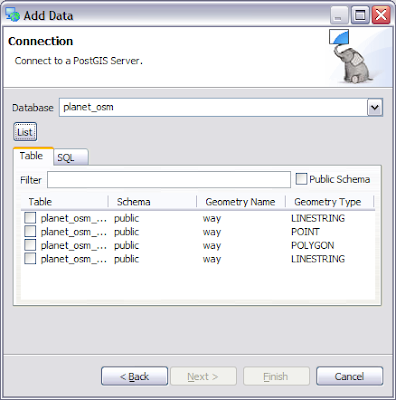
Because this is going to be a public showcase; and PostGIS implements an OGC standard here are the connection details (for read-only access as shown below – use the credentials readonly/readonly):

Mark has loaded up some example datasets from GeoScience Australia:

And Open Street Maps:

(The Australian Bureau of Meteorology data is mostly raster so we will need to cover that when we set up GeoServer in a later blog post).

Mark has gone above and beyond the call and duty; for details on these datasets please see the table description. This is so rare that one of the first things I am going to have to do is patch uDig to show me the table descriptions.

Documentation

One of the first steps to take when stepping out of your comfort zone is a quick search; looking for docs and so on.

I was able to find this: GeoServer in Production Environment

The second step is to check the date of the documentation; in this case Chris had made a change on Feburary 11th which sounds recent enough to trust.

Developers

The third step was to jump on the IRC channel and let people know what I was up to; in order to tease out any "gotcahs" that only the developers (or email list) know about.

Our happy GeoWebCache maven "arneke" was able to point out two bits of wisdom:

  • do not trust the tomcat that comes with the distribution; you should download your own tomcat; or

  • "configure it" the default tomcat to work

In this case configure it refers to the following bug report: GEOS-1567

And the easiest workaround in the list is to edit the webapps policy.d file and add the following line: “permission java.security.AllPermission;” This line grants geoserver the same permissions as a desktop application allowing it to check environmental variables (it uses this to locate the geoserver data directory where all the configuration information is stored).

Leasons Learned – use Tomcat Manager

Next up for me is the question; where do I drop the war? This is the kind of "basic" question that is hard for documentation to answer - since they assume you know that part already.

In Tomcat on windows (or indeed many application servers) there is a webapps folder you can drop your war into and it will be unpacked and executed.

In debian there were three candidate locations:

  • /etc/tomcat6 - this is where the configuration on logging settings are kept; no sign of a webapps folder

  • /var/lib/tomcat6/webapps - this has a single entry "ROOT"

  • /usr/share/tomcat6/webapps

So what is going on? It looks like they are separating out the application container; from the various web applications.

Andrea recommended using /var for external data directory. It was at this point that I found the War-File install page. And then a series of good blog posts:

These blog posts seem to be serving as unofficial documentation on the subject right now.

Turns out the answer to my question was - to use the Tomcat Web Applicaiton Manager; which will unpack things ... into /var/lib/tomcat6.

And a bit of Work

Tomorrow I will talk about configuring GeoServer; you can learn about the dangers of uding an Experimental PostGIS; and I will let you know where you can try out the final result.

Monday 2 March 2009

FOSS4G 2009 In Brief

In brief:
  • http://2009.foss4g.org/workshops/
    Workshops 3 hours hands on in a computer lab setting. Why do this? Your ticket to FOSS4G should be paid for; you can bring an assistant and they may also be paid for (depending on profits)
    March 9th
  • http://2009.foss4g.org/tutorials/
    Tutorial 90 min session in a bring your own laptop setting (hopefully you can use the conference live DVD and/or windows installers). Hands on is recommended; but you can also just talk a lot. So far this is the easiest way to get speaking time at the confernece
    March 9th
  • http://2009.foss4g.org/presentations/
    Presentations 30 mins just talking (you can try for a 3 min demo but that is risky). Competition for presentations slots is stiff.
    June 1st
  • (only if I get organized)
    Demo theatre 10 mins showing running software (not slides)
    September 1st