This was the second foss4g-na done as a joint Open Source Geospatial Foundation and LocationTech event. As a member of both organizations a lot of my time at the conference was spent fielding questions on how this collaboration takes shape. I was not always able to give a clear answer, as I tend to focus more on the individuals than the process.
There is of course a document with the details. The quick answer a "core committee" starts the ball rolling. The "core committee" is responsible for sorting out a venue, selecting a logistical organizer and electing a conference chair. This is where the collaboration comes in as the "core committee" is made up of an OSGeo representative (Marc Lucas), LocationTech representative (Jim Hughes) along with three prior conference chairs (for continuity).
The "core committee" selects a venue by RFP, inviting venues to respond, shortlisting results, and reviewing the top locations reviewed in person. This year it was a tight race between a bid from Philadelphia (which ended up being too small) and from Raleigh, where the event was held.
The final question is who runs the event? This time it is a conference committee, headed up by Andrea Ross who was elected conference chair. Responsibilities were divided up with Andrea rounding up all the behind the scenes work as producer (made exciting by responding to HB2). Rob Emanuele acted as program chair pulling together public feedback, balancing the program and the all important scheduling. Sarah Cordivano volunteered as community chair leading the proceedings as spokesperson for the event.
A big thanks to the organizers of FOSS4G-NA 2016 for your hard work, and thank you for the great event!
The regional FOSS4G-NA event was held last month in Raleigh North Carolina. The event was amazing with a diverse program and perfect conference weather (and breaks between sessions) to encourage conversations!
FOSS4G-NA on the web:
FOSS4G-NA 2016 - conference website with links to slides and videos
FOSS4G-NA Flickr Group - okay so I took most of the photos (easier than writing a blog post)
Thoughts on FOSS4GNA 2016 - Kurt Menke (Bird's Eye View) provides a wonderful personal account on what the foss4g event means to the community and conference highlights.
FOSS4GNA 2016 First Post, People and Synopsis - Randal Hale (North River Geographic Systems) captures how foss4g stays relevant with a charming mix of anecdotes.
Thoughts on FOSS4G NA 2016 - Joshua Campbell (Disruptive Geo) with an insightful take on the tools, data and visualization being explored at the conference.
FOSS4G NA 2016 Review - Peter Batty (Geospatial Division) a slide deck with conference highlights
BOS4G#4 (audio|text) - Guido Stein (Applied Geographics Inc.) exploring the foss4gna event, HB2 and the upcoming FOSS4G 2017 in Boston
On the Ground
These blog posts are always a challenge to write - as FOSS4G events are a real community effort with many people to thank.
I would like to start by thanking Boundless for sending me (and many colleagues) to the event. We had a great time, often meeting each other for the first time and spending time with our community projects.
Thanks to the foss4g-na organizing committee for pulling together such a great event. Leadership fell to Andrea Ross, Rob Emanuele and Sarah Cordivano this year and they did an amazing job. Thanks to the OSGeo and LocationTech for providing a productive space for the community - both in the form of this event and also online (if you are unsure how foss4g-na is organized I made a blog post with a picture).
A big thanks to the open source projects represented at foss4g-na. It was really great to see a wider range of projects represented this year with both core developers and and a strong power-user presence in the conference program.
Finally thanks to all the delegates, especially those new to the event. Your enthusiasm inspires us all.
Raleigh, HB2 and Diversity
The city of Raleigh was welcoming, with a walkable downtown core. On the weekend the main street was blocked off for a food truck rodeo. The weather cooperated with some quite vigorous rain to keep delegates indoors during the sessions.
I was concerned that the HB2 shenanigans would provide a hostile environment for the conference. As it was this placed some prospective attendees under travel restrictions. The conference synopsis showed reasonable diversity with as always room for improvement.
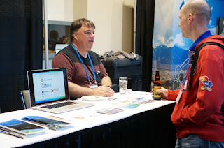
OSGeo Booth and Exhibit Area
As a new OSGeo board member I got to set up shop with Michael Smith at the OSGeo booth (and join in the hunt for banners, brochures and stickers). With the Boundless booth fully occupied I had a chance to hang out here far more than anticipated and was rewarded with lots of questions, a fair bit of banter and some great discussions.
It was a bit of a scramble getting conference materials together, but Michael is good company in a scramble. I feel we did a good job representing OSGeo. Thanks to the marketing committee for helping us get set up.
Conference Program
The conference was run smoothly and I was really glad to see how balanced the program was. Breaks were long enough that you were never pressed for time getting between rooms. I only saw one relatively empty room (a presentation of interest to the local North Carolina community) and the one empty block in the program was quickly filled by an enthusiastic volunteer.
Highlights
The highlight of any of these events is of course the people, the conversation and the connections. You could track a buzz as the sessions let out with people tried out new ideas, compared notes, and searched for coffee before the next session.
Workshops
I started the week with the GeoNode Developers Workshop (a team effort from Jeff Johnson, Tyler Garner and Daniel Berry). The workshop introduced the application and provided many opportunities for questions. It was a bit difficult to follow as the tutorial did not always line up with the version of GeoNode we were using. Still it was great to see the application in action.
I got to help out Mike Pumphrey with the Introduction to GeoServer workshop. Mike seriously did all the talking (four hours straight). Even when he let everyone out for a coffee break he would stay behind answering questions. My task was easy by comparison - helping anyone who had fallen behind (usually due to installation issues or missing a step). This workshop was especially exciting as we were able to crank up the amount of styling covered (making use of human readable styling in the form of YSLD).
Day 1
The keynotes for the event were well received. Monday started with Jerry Johnston discussing the US National Spatial Data Infrastructure. Response ranged from horror at an SDI still being shown via a portal in 2016 to shock at how much the government has accomplished as part of this program. Kudos to Jerry for demonstrating live fresh-this-morning functionality, which made for a great bonding moment with the audience.
Personally my first talk was Welcome to the FOSS4G Community (video|slideshare|pdf) introducing not just what makes these events so much fun, but more importantly what makes these events possible. This was an expanded intro talk (for universities and local events) on what it means to be "open". There were two highlights - 90% of those in the room were at their first foss4g event (no pressure then) and the crowd was kind enough to ask questions during the presentation.
My next talk, A new vision for OSGeo (video|slides|pdf). was more challenging. The OSGeo board met in January to do a bit of planning - updating the foundation mission and revising our goals for the next ten years. I had intended to do this as a joint talk with Helena (who is both amazing and a Raleigh local) to cover the results of the 2016 strategic plan. That did not quite work out as planning is ongoing! The resulting talk was perhaps better - covering the new mission, 2016 budget, recent progress and this year's objectives.
Throughout the day you could watch delegates buzzing with new ideas as they emerged from the sessions.
Gretchen's talk on Awaken the QGIS Within (video) had people all wound up with lots of references on twitter.
In a similar fashion people were thrilled to meet Larry in the State of QGIS Project talk (as there are not that many QGIS developers in North America).
A number of my fellow Boundless colleagues emerged disappointed from a canceled session on Python D&D Map Generation they were looking forward to (professionally of course).
The second day dawned with what was probably the highlight of the conference, a keynote from Tamar Cohen looking at Extreme Mapping at NASA. The keynote had everything from crashing probes into the moon (for science!), amazing stories of slow robots, to call outs to the open source software used (each one of which would cause a flurry on twitter).
The following talks were recommended:
Portable OSM had my colleagues talking during the break, capturing a powerful use case for the Red Cross. Unplugging OSM onto a portable server for fieldwork and using smartphones for data collection.
Cartography in Inkscape (video) was a firm reminder that cartography matters (filling in the D&D shaped hole from the first day). The presentation covered export SVG export from QGIS and cleanup and tricks for making the final map in a drawing program.
Jim Hughes brought the math to the big data track with a talk on GeoMesa, GeoBench and SFCurve (video). There are entertaining animations to make the math easier to follow.
I enjoyed the GeoSHAPE presentation (video) and especially appreciated the architectural diagram (showing how the components fit together) and an example of a three way GeoGig merge.
The Hiroshima Archive presentation hit home emotionally, while offering an example of migration from Google Earth to Cesium.
"TheSteveO" had fun using GeoServer as an example of a monolithic application for Microservices and You - the straight dope (video). Thanks for the encouragement Steve - although there is plenty of ideas we have in mind.
Joe Allnut from Ordinance Survey gave a presentation on GeoGig (video) which included a live demo and his experience testing the technology with larger datasets.
Many attendees followed Tamar Cohen's keynote presentation up with an afternoon session on Finding Stuff underwater (video).
I was impressed with Maggie Cawley filling in a hole in the program with Cheet'n Death talk prepared minutes before in the hallway. These stories of open source acting as an enabler are great.
Day 3
The last keynote provided an optimistic approach to our mapping community. Michael Tiemann used passion, and a farming metaphor, to champion sustainability as a requirement for a successful open source community.
The last day was shorter:
Lyzi Diamond gave a high powered talk on WTFGL (video) reviewing web mapping from MapQuest through to vector tiles and WebGL. A great presentation, a packed room, and adorable animal pictures.
The next presentation was a show down with Lauren Ancona vs the Pope in the form of PhillyPopeMap showing how much an individual can do, cartographic activism and one great sticker!
Dave and Andreas chose the last slot of the day to cover Vector Tiles support in GeoServer and OpenLayers (video) - to a full house (with standing room only at the back). Dave provided an easy (but quick) intro to how vector tiles function, covering some of the data prep and GeoServer configuration required. Andreas brought this all together with OpenLayers examples and a live demo.
The conference wrapped up with some excitement for upcoming foss4g events including foss4g 2016 in Bonn and foss4g 2017 in Boston. The organizers took a well deserved bow - thank you for the great event.
Code Sprint
The code-sprint was a considerably more relaxed affair taking place after the main conference.
There were a couple presentations (during the coffee break) and the expected amount of internet, laptops held together by stickers, good cheer and dancing lessons.
LocationTech projects encouraged each other through incubation with the GeoTrellis team making visible project. I helped the GeoGig project, untangling a GeoTools startup failure if JAI was not installed). Thus inspired I started putting together a formal proposal for an open source tiling engine.


